

Skyway, Chinnabee, Pinho Loop
Adam’s Gap Trailhead on AL 281 South, only 3.8 miles south of
Cheaha State Park.
Hospital
Tanner Medical Center/East Alabama
1032 Main St S, Wedowee, AL 36278
+12563572111
Clinic
Clay County Medical Clinic
60026 AL-49, Lineville, AL 36266
+12563962141
Call 911
Call Ranger Station
- Talladega Ranger District
- (256)362-2909
Call Emergency Contact
Head to nearest campsite or road crossing
Always yield to emergency responder directions
Do not hike in severe weather, seek shelter.
Don’t forget to check the weather before you leave.
Look For:
- lightning
- Tornado conditions
- flash flood warnings
- watch the radar prediction.
Do not interact with wildlife. Maintain a safe and respectful distance.
Remember Leave No Trace:
- Plan ahead and Prepare
- Camp and Travel on Durable Surfaces
- Dispose of Waste Properly
- Respect Others
- Respect Wildlife
- Minimize Campfire Impact
- Leave What You Find
trail data.
Trails Covered ~ Pinho Trail, Chinnabee Silent Trail, Skyway Loop Trail
Hike Location ~ South Cheaha Wilderness
Hike Direction ~ Counter Clockwise
Hike Distance ~ 16.7 miles
Start / Finish Hike ~ Adams Gap Trailhead
Terrain / Difficult ~ 0.0 ~ 8.0 rocky climbs and descents, rock bluffs and rock gardens.
Moderate ~ 8.0 ~ 16.7 rolling hills. There are 3 moderate size creek crossings in the Chinnabee and Skyway area, use extreme caution after heavy rains.
hiker services.
CS ~ Convenience Store / Nice Mom and Pop stores ~ 0
TT ~ Trail Town / Large enough for McDonald's ~ 0
SC ~ Small Campsite / At least one tent site ~ 4.4
LC ~ Large Campsite / At least three tent sites ~ 3.1, 4.8, 5.4, 5.8, 6.0, 7.6, 7.8,
9.0, 11.0, 12.7, 15.7
TS ~ Trail Shelter / Three sided, open front ~ 9.2
SW ~ Seasonal Water / Needs rain in the past week ~ 1.2, 2.5, 3.2, 5.5, 5.9, 6.0,
6.9, 8.2, 16.4.RW ~ Reliable Water / Always available ~ 7.6, 9.0, 11.0, 11.4, 12.7,
12.8, 15.7
Trail Description:
For an easier hike, walk the loop clockwise . Please note that the following directions
are for a counter-clockwise hike.
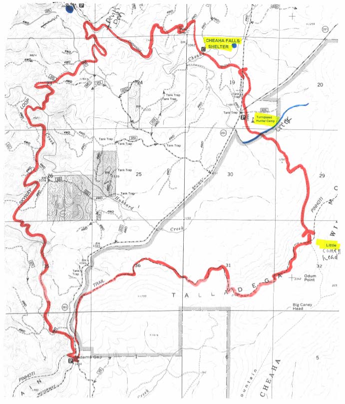
This 16.7 mile counter-clockwise loop begins at the southwestern end of the Cheaha
Wilderness at the Adams Gap Trailhead. From the parking area, you'll cross over AL
281 and go down the small downhill paved road about 10 feet to the Pinho Trail. Turn
left on the Pinho and hike 6.0 miles to the Little Caney Head Campsite. Then turn
left on the Chinnabee Silent Trail and hike 5.4 miles to Lake Chinnabee. Just before
the lake you'll turn left on the Skyway Loop Trail and then hike 5.1 miles to the
Pinho Trail. Turn left on the Pinho and hike 0.2 miles to the Adams Gap Trailhead.
Trail Marking:
Wilderness Standards do not allow trail blazing in protected areas ~ mile 0.0 thru
8.0.
The western half of the Chinnabee and all of the Skyway Trail are well blazed.
me vs distance
To help you judge the me needed to travel from point A to point B,
consider that the average hiking pace is 2 mph:
60 minutes = 2 miles
30 minutes = 1 mile
15 minutes = 1/2 mile
driving directions.
0.0 ~ ADAMS GAP TRAILHEAD
Exit I ~ 20 at US 431, east of Oxford.
Go south 3.4 miles to the overhead bridge.
Go 100 yards past the overhead bridge to the second right turn, just before the Cheaha
Store. Turn right.
Go 0.4 miles to the stop sign at AL 281. Turn le.
Go 17.9 miles to where the pavement ends at the Adams Gap Trailhead parking area.
trail guide.
0.0 ~ ADAMS GAP TRAILHEAD / AL 281 ~ 1444'
From the parking area, cross over AL 281 and go down the small downhill paved road
for about
10' and turn le up the hill into the Cheaha Wilderness.
0.1 ~ CHEAHA WILDERNESS BOUNDARY / INFO BOARD ~ 1500'
1.2 thru 2.5 ~ 6 SPRING CROSSINGS ~ 1360' +/- ~ SW
3.1 ~ CAMPSITE ~ 1380' ~ LC, SW
There is a fire ring here on the le and the spring crossing is at mile 3.2.
3.2 ~ SPRING CROSSING ~ 1360' ~ SW
3.5 ~ SIGN BOARD / ROAD BED ~ 1460'
The trail turns right on the road bed and goes 0.2 miles.
3.7 ~ SIGN BOARD ~ 1575'
The trail goes back in the woods on the le. This sign board is off trail 10' on the
le and is easy to miss.
3.7 ~ STAIRWAY TO HEAVEN ~ 1575'
Here is a huge rock garden and there are a lot of tricky little uphill rocky
switchbacks for the next 0.5 miles. Keep a close watch on the blazes!
4.3 ~ PEARLY GATES ~ 2050'
You will have to see it to believe it. Yikes!
4.4 ~ HEAVEN / ROCKY TOP 4 ~ 2135' ~ SC
There is a hidden rocky overlook on the le as you scramble your way around the
north side of the peak.
WILDFLOWER ~ Mountain Laurel / Late Spring / White.
4.8 ~ 5.4 ~ 3 CAMPSITES ~ 2100' +/- ~ LC ~ Good views
5.5 ~ SPRING CROSSING ~ 2140' ~ SW
5.7 ~ ROCKY TOP 5 ~ 2160'5.8 ~ CAMPSITE ~ 2120' ~ LC ~ Good views
5.9 ~ SPRING CROSSING ~ 2120' ~ SW
6.0 ~ LITTLE CANEY HEAD CAMPSITE / CHINNABEE SILENT TRAIL ~ 2100' ~ LC, SW
Turn left at this big intersection on the Chinnabee Silent Trail and start working
your way down off the ridge.
LC ~ Little Caney Head is a busy place with 6 fire rings.
SW ~ The spring is 50' down the CST, on the le. This is a high ridge spring and therefore
it is reliably unreliable year round - plan accordingly.
WILDFLOWER ~ Mountain Laurel / Late Spring / White
6.9 ~ SPRING CROSSING ~ SW
The spring is off trail about 50' to the right, through a Mountain Laurel thicket.
You'll be able to hear it a lot beer than you can see it.
7.6 ~ CREEK CROSSING ~ LC, RW
7.8 ~ TURNIPSEED HUNTER'S CAMP ~ LC, RW
The trail goes straight across the camp road. You can go right on the road about 50
yards to a new outhouse.
8.0 ~ AL 281 CROSSING / PARKING AREA
The trail goes straight across the road.
8.2 ~ SPRING CROSSING ~ SW
Cross the spring and the trail turns left.
8.5 ~ SKYWAY MOTORWAY CROSSING
The trail goes straight across the road.
9.0 ~ CHEAHA FALLS ~ LC, RW
Cross the creek and the trail turns left. The falls are downstream 50' to the le.
LC ~ There is a large campsite on the right, before the creek crossing.
FORDING HAZARD: Use extreme caution after heavy rains.
9.2 ~ CHEAHA FALLS SHELTER ~ TS
The trail turns sharp right just past the shelter. This shelter was formerly known
as the Little Caneyhead Shelter. It was flown over here by helicopter in 1993 from
the Little Caneyhead campsite.
The water source for the shelter is Cheaha Falls.
10.5 ~ PINE BEETLE CUT
11.0 ~ CAMPSITE ~ LC, RW
Look for the camp down on the le.
11.2 ~ DEVIL'S DEN FOOT BRIDGE
This 75' bridge has good views of the chaos below in Devil's Den.
11.4 ~ TRAIL SIGN / SKYWAY LOOP TRAIL INTERSECTION ~ RW
Continue on for another 50' past this sign to the Skyway Loop Trail sign. Turn le
here and cross the creek.
FORDING HAZARD: Use extreme caution after heavy rains.
12.0 ~ ROAD BED CROSSING
12.2 ~ ROAD BED CROSSING
12.7 ~ CAMPSITE ~ LC, RW
Look for a trail on the right leading to the camp.
12.8 ~ HUBBARD CREEK CROSSING ~ RW
FORDING HAZARD: Use extreme caution after heavy rains.
13.7 ~ ROAD BED CROSSING
14.7 ~ ROAD BED CROSSING
15.7 ~ CAMPSITE ~ LC, RW
The campsites are on the right and left.
15.8 ~ CIVILIAN CONSERVATION CORPS CHIMNEY
Many years ago there was a CCC Park Cabin on this spot. Keep an eye out for the uphill
switchbacks ahead.
16.4 ~ SPRING CROSSING ~ SW
16.5 ~ PINHOTI TRAIL INTERSECTION ~ 1400'
When you come to the intersection, turn le on the Pinho and follow the rocky
trail up to the gap.
16.7 ~ ADAMS GAP TRAILHEAD ~ 1444'
For this trip you’ll need at least 4 meals.
Veggie Wraps:
- hummus, tortillas, tomato, spinach, cucumber, and cheese
- Spaghetti noodles, sauce, green pepper, mushrooms
Granola - granola, evaporated milk (add water), dried berries
Ramen Soup - ramen, mixed veggies, curry, coconut milk